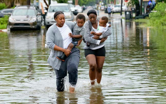
The streets of New Orleans were flooded Wednesday night as a slow-moving storm system approached the city. But with even more rain expected to deluge the Crescent City over the next three days, concerns are growing that the worst is yet to come.
The Associated Press, citing data from the National Hurricane Center, writes that the storm system could evolve into “a tropical depression by Thursday morning, a tropical storm by Thursday night and a hurricane on Friday.” As of Thursday morning, parts of the city were under an emergency flash flood warning.
According to the AP, the flash flooding overturned garbage cans and picked up debris; flood water rose as high as three to four feet in some neighborhoods, prompting people to abandon their cars or take to kayaks to make their way down some streets. A tornado warning went into effect at one point on Wednesday.
But the worst-case scenario involves storm surges that would elevate the Mississippi River to 20 feet above sea level, the same height as the levees protecting New Orleans.
The extent to which New Orleans will be affected—and how devastating the impact of a potential Hurricane Barry will be—rests on how high the Mississippi River’s waters will reach. Here’s Slate’s breakdown of where the river stands now, and where it typically is at this time of year:
A rain forecast like Barry’s is never welcome news in New Orleans. But what makes this storm particularly ominous is that it comes at a time when the Mississippi River in New Orleans is just below flood stage, an unusual and unprecedented development this late in the year. As I wrote in June, the river—swollen by a record year of rainfall in the Midwest—has never been so high, so long. A few feet of rain and a midsized storm surge are projected to bring the river to a height it hasn’t hit in more than 90 years, reaching the top of the levees. Another foot would cause river water to crash into the neighborhoods below. Katrina hit when the river was running at 3 feet; it currently sits at 16 feet.
Ricky Boyett, a spokesperson for the Army Corps of Engineers in New Orleans, told the AP the agency is concerned about areas south of the city, but that it wasn’t expecting water to top the levees in most parts of the city.
“We’re confident the levees themselves are in good shape. The big focus is height,” Boyett said.
City officials have told residents in the area to stock up on at least three days of supplies, the AP reports, as well as keep neighborhood storm drains clear to help the water pass quickly.

